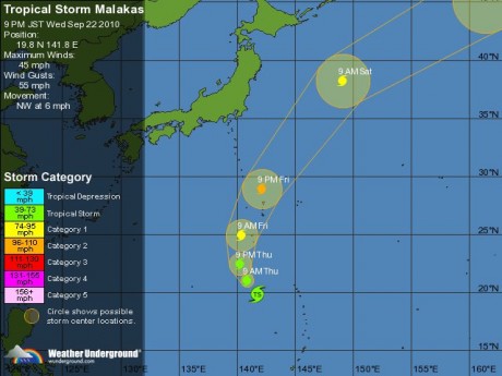
Τυφώνας με όνομα Malakas κατευθύνετε στα νησιά της Ιαπωνίας
και το άρθρο για τον τυφώνα , στα Αγγλικά
Tropical Storm Malakas has strengthened as it tracks north over the Pacific Ocean on course to brush past the east coast of the main Japanese island of Honshu in two days, according to the Japan Meteorological Agency.
The agency’s forecast shows the typhoon churning toward the islands of Iwo Jima and Chichi Jima before turning north- northeast, indicating it won’t make landfall on Japan’s main islands. The storm is estimated to make its closest approach about 390 kilometers (242 miles) off Hachijojima island, south of Tokyo, at around 9 a.m. on Sept. 25, the agency said on its website.
Malakas is expected to gain strength in the coming two days to maximum winds of 55 meters per second (123 miles per hour) from 40 meters per second, with a storm warning area extending about 440 kilometers, the Japanese weather service said. The storm’s intensity will probably weaken to an extra-tropical cyclone by 9 a.m. on Sept. 26, it said.
Malakas was 500 kilometers south of Iwo Jima moving slowly north-northwest at noon Japan time today, the agency said.
Malakas means “strong” or “powerful” in the Philippines, according to the Hong Kong Observatory, which lists names assigned to storms in the northwest Pacific and South China Sea. Malakas is the 13th storm of the northwest Pacific season.
To contact the reporter on this story: Mariko Yasu in Tokyo at myasu@bloomberg.net.
To contact the editor responsible for this story: Jim McDonald at jmcdonald8@bloomberg.net


 (-1 σκόρ, 1 ψήφοι)